
Condition Report
Contact Information
Lot 298
Sale 945 - Fine Printed Books & Manuscripts, Including Americana
Lots 1-307
Nov 9, 2021
4:00AM CT
Lots 308-687
Nov 10, 2021
4:00AM CT
Live / Chicago
Own a similar item?
Estimate
$2,000 -
3,000
Price Realized
$1,250
Sold prices are inclusive of Buyer’s Premium
Lot Description
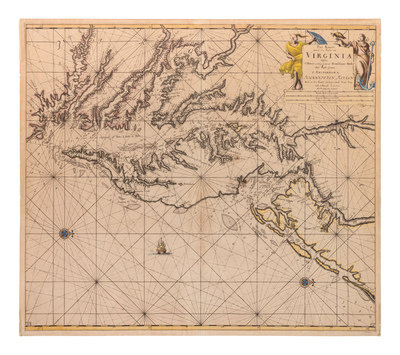
KEULEN, Johannes van (1654-1715). pas Kaart Van de Zee Kusten van Virginia Tusschen. Amsterdam, ca 1695.
Engraved map with hand-coloring in outline of the Chesapeake and Delaware Bay region, 530 x 603 mm sheet. Figural cartouche, galleon, compass roses. (Some overall browning, a few short tears occasionally crossing image.)
A rare coastal chart based on Augustine Hermann's map of 1670. North is oriented to the right in the map, and the map shows the shoreline from Cape Henry to southern New Jersey and Pennsylvania. Place names are included along the shoreline, including the new settlement of "Filadelfy" (Philadelphia).