

Condition Report
Contact Information
Auction Specialist
Lot 233
Sale 6330 - Fine Printed Books & Manuscripts, Including Americana
May 8, 2025
10:00AM CT
Live / Chicago
Own a similar item?
Estimate
$2,000 -
3,000
Price Realized
$2,880
Sold prices are inclusive of Buyer’s Premium
Lot Description
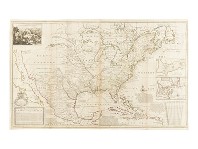
[MAP]. MOLL, Herman (1654-1732). A New Map of the North Parts of America claimed by France under ye Names of Louisiana, Mississippi, Canada and New France... London: Sold by H. Moll…in the Strand…sold by Tho: Bowles…in St. Paul’s Church Yard, John King…in ye Poultry…and John Bowles at the Black Horse Cornhill, 1720.
Large engraved map on two joined sheets with hand-outlining in color, 622 x 1016 mm. Vignette of “The Indian Fort Sasquesahanok” and vignettes of “The Harbour of Annapolis Royal”, and “A Map of ye Mouth of Mississippi and Mobile Rivers”. (Folds reinforced and a few scattered repairs on verso, toning to folds.)
“THE MAP PRESENTS DETAILS OF THE SOUTHEAST FOUND IN NO OTHER PRINTED MAP” (Cumming).
Moll’s map is largely based on Delisle’s famous map of 1718 and shows California as an island, and a vast section of the West is identified as “Parts Unknown”. Siebert’s second state with “the” in the title, and with the inset of the Sasquesahanok Indian fort uncolored. Cumming, p.23; McLaughlin 183; Phillips Atlas I:554; Siebert sale 673; Streeter sale I:119; Wheat 105.
Property from the Estate of James G. Hansen at Fetcher House, Winnetka, Illinois