
Condition Report
Contact Information
Auction Specialist
Lot 234
Sale 6330 - Fine Printed Books & Manuscripts, Including Americana
May 8, 2025
10:00AM CT
Live / Chicago
Own a similar item?
Estimate
$2,000 -
3,000
Price Realized
$3,840
Sold prices are inclusive of Buyer’s Premium
Lot Description
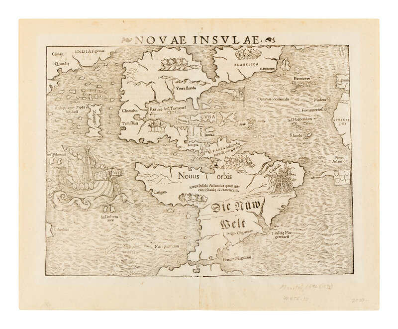
[MAP]. MUNSTER, Sebastian (1489-1552). Novae insulae. Basel, 1572.
Woodcut map of North and South America, 12 3/4 x 16 inches. Large vignette of a ship. Kershaw State 12, with title change "Novae Insulae" and the final form of the label in South America. (Some marginal toning, hinged to mat.)
First issued in 1540, Munster's map is the earliest map to depict all of the Americas, and the first to name the Pacific Ocean ("Mare Pacificum"). The ship is Magellan's Victoria, the only vessel of five to survive his voyage. Munster relied on Verrazano's accounts of the New World and on Marco Polo's accounts of eastern Asia when producing his map. The map first appeared in the 1540 edition of Münster's Geographia. However, it was its inclusion in the 1544 edition of Münster's Cosmographia that cemented "America" as the name for the New World, perpetuating Waldseemuller's choice of names in a popular and widely disseminated work. Burden 12; Kershaw 12c; Tooley, p.112.