Condition Report
Contact Information
Auction Specialist
Lot 225
Sale 6330 - Fine Printed Books & Manuscripts, Including Americana
May 8, 2025
10:00AM CT
Live / Chicago
Own a similar item?
Estimate
$1,000 -
1,500
Price Realized
$2,048
Sold prices are inclusive of Buyer’s Premium
Lot Description
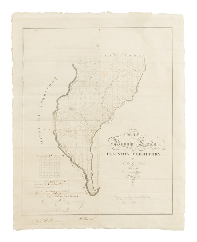
[MAP]. GARDINER, John. Map of the Bounty Lands in Illinois Territory. Washington, D.C., 1817.
Engraved map, 533 x 432 mm. Lower portion of text accomplished in manuscript and signed by Gardiner, with the inscription "Gently rolling good soil", also signed by Andrew Williams and Mr. Duvall; each block of land annotated with identifying letters or symbols. (Old folds with few small repairs verso, large closed tear to upper blank portion of map with small loss near border repaired.) Provenance: John W. Yates (signed on verso, notations), presumably one of the War of 1812 veterans these maps were sent.
ONE OF THE EARLIEST OBTAINABLE MAPS TO NAME ILLINOIS. Second issue, with the printed “townships maps” in lower left corner.
Congress passed an act in May 1812 that set aside lands in what is now Arkansas, Michigan, and Illinois as payment for service in the War of 1812 (and had done so after the Revolution, but those lands were in the Northwest Territory). Not only was it a way to pay veterans without needing a cash outlay, but it also continued the westward expansion of the nation and helped to "civilize" these lands. Illinois became a state in 1818 in part because of this rapid influx of settlers.
John Gardiner was the chief clerk of the GLO during the War of 1812 (and he is credited with saving the records by taking them out of Washington when the British attacked). He composed several maps of the available lands, and in December 1818, he proposed that Congress give all War of 1812 veterans a copy of the maps with available bounty lands. Congress passed on this suggestion. This may be part of the reason he started describing all the lots himself on each copy of the maps that were sent to veterans. The process had to be shortened (obviously), so parts of the descriptions were preprinted.
Streeter 1430 ("This is the first map that Phillips lists under Illinois, and it is perhaps the first map showing a considerable part of Illinois with "Illinois" in the title).
Property from the Estate of James G. Hansen at Fetcher House, Winnetka, Illinois