
Condition Report
Contact Information
Lot 302
Sale 588 - Fine Books and Manuscripts
Nov 13, 2018
9:59AM
Live
Own a similar item?
Estimate
$400 -
600
Lot Description
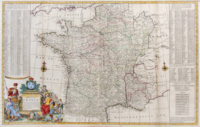
MOLL, Herman (1654?-1732). A New and Exact Map of France. London, [ca 1730].
Engraved map of France, image 604 x 968 mm (sheet 628 x 995 mm) with hand-coloring. Allegorical cartouche depicting the arts, sciences, and viniculture, with the observatories at Paris and Greenwich visible in the background; also with alphabetical table, distance table, and list of ports of passage of the Pyrenees Mountains.