
Condition Report
Contact Information
Lot 301
Sale 588 - Fine Books and Manuscripts
Nov 13, 2018
9:59AM
Live
Own a similar item?
Estimate
$400 -
600
Price Realized
$313
Sold prices are inclusive of Buyer’s Premium
Lot Description
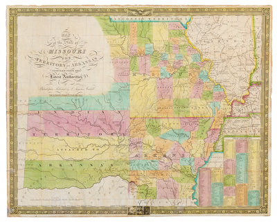
MITCHELL, Samuel Augustus (1792-1868). Map of the State of Missouri and Territory of Arkansas. Philadelphia, 1836.
Engraved map hand-colored in wash and outline, 461 x 577 mm sheet. Inset table of steamboat routes. (A few short separations at folds or marginal chips, some with associated repairs, some mostly marginal browning.) Later edition, first published in 1831, derived from Finley's 1826 American Atlas map, incorporating changes to the overall topography and the Arkansas border. Rumsey 4102.