


Condition Report
Contact Information
Lot 139
Sale 6465 - Printed and Manuscript Americana
Jan 29, 2026
10:00AM ET
Live / Philadelphia
Own a similar item?
Estimate
$3,000 -
5,000
Price Realized
$3,840
Sold prices are inclusive of Buyer’s Premium
Lot Description
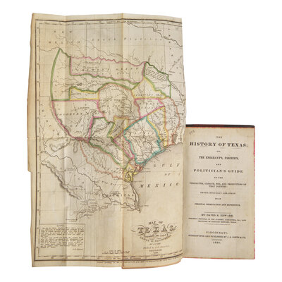
[Texiana] Edward, David B(arnett). The History of Texas; or, The Emigrant's Farmer's and Politician's Guide to the Character, Climate, Soil and Productions of that Country...
Cincinnati: Stereotyped and Published by J.A. James & Co., 1836. First edition. 12mo. 336 pp. Illustrated with engraved folding frontispiece map of Texas with hand-colored outlining. Three-quarter late 19th-century black morocco over brown cloth-covered boards, stamped in blind and in gilt, light wear to cloth and morocco; marbled edges; patterned endpapers; tape repair in gutter of map, wear along edges of same; small dampstaining in top corner of some leaves at front. Clark III:35; Graff 1208; Howes E-48; Jenkins, Basic Texas Books 53; Reese, Best of the West 65; Sabin 21886; Streeter Sale 1:334; Streeter, Texas 1199
An important first edition of "one of the essential Texas books" (Streeter), published the year the Republic of Texas became a sovereign nation, and with the rarely seen hand-colored
map of the state.
Edward moved to Texas in 1830 and recorded detailed observations and descriptions of Texas in this classic early history of the state. The fine map by Lee is adapted from a later issue of Stephen Austin's seminal map of Texas and must have been completed shortly
before publication because it notes the death of Benjamin Rush Milam (1788-1835) at the Siege of Bexar. "One of the few choice early histories of Texas, though the author was rather Mexican in his politics. Among the rare public documents inserted, are the proposed constitution of Texas drawn up in the convention of 1832-33, and the Mexican constitution of 1824. Specifically valuable for full treatment of the times just before the Revolution." (Raines, p. 74)
"The map shows towns, rivers, colonies, grants, Indian villages, mountains, roads, silver mines in Mexico and on the San Saba River, iron ore, copper mine, note on Col. B. R. Milam's death, comments on wild life and topography, salt works on Galveston Bay, site of
General Toledo's defeat in 1813. There is also a printed note by D. B. Edwards on the Rio del Norte, its navigability and its possibilities as a southwestern boundary for Texas." (Day, Maps of Texas 388)
This lot is located in Philadelphia.