
Condition Report
Contact Information
Lot 280
Sale 6426 - Fine Printed Books & Manuscripts, Including Americana
Nov 13, 2025
10:00AM CT
Live / Chicago
Own a similar item?
Estimate
$800 -
1,200
Price Realized
$640
Sold prices are inclusive of Buyer’s Premium
Lot Description
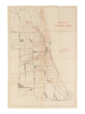
[MAP]. THRASHER, Frederic M. (1892-1962). Chicago’s Gangland… 1923-26. Chicago: The University of Chicago Press, 1927.
Offset lithograph thematic map printed in red and black, 648 x 445 mm (small splits to folds, a few repaired on verso); folding into original envelope.
FIRST ISSUE, with text in lower margin. Issued to accompany sociologist Frederic Thrasher's seminal 1927 study, The Gang: A Study of 1,313 Gangs in Chicago (seen here), the map depicts the locations of youth gangs in the "poverty belt," rather than focusing on Capone's Mob. Thrasher applied thematic mapping to depict organized criminal activity to help support his thesis that such activity thrives in urban spaces. His concern was that second-generation immigrant children evolved from “play groups” and into youth gangs. His central conclusion was the identification of a place called “Gangland” … “a geographically and socially interstitial area of the city”. Numerous notations printed in red provide added detail of gang territories that include “Hobohemia” in the Gold Coast, “Jewish-Polish Frontier” in Douglas Park, and “Slave Town” in what is now Randolph Street Market.
[Laid into:] THRASHER. The Gang: A Study of 1,313 Gangs in Chicago. Chicago: The University of Chicago Press, 1927. 8vo. Original tan buckram, orange printed paper labels on upper cover and spine (lacking front free endpaper, spine sunned, hinges tender). FIRST EDITION.
This lot is located in Chicago.