
Condition Report
Contact Information
Auction Specialist
Lot 227
Sale 6330 - Fine Printed Books & Manuscripts, Including Americana
May 8, 2025
10:00AM CT
Live / Chicago
Own a similar item?
Estimate
$1,000 -
1,500
Price Realized
$3,840
Sold prices are inclusive of Buyer’s Premium
Lot Description
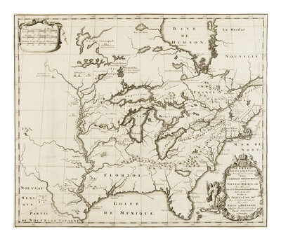
[MAP]. HENNEPIN, Louis (1640-1704). Carte d'un tres grand pais nouvellement decouvert dans l'Amerique Septentrionale. Utrecht: G. Broedelet, 1697.
Engraved map, 381 x 445 mm. Decorative cartouches. (Trimmed close to neatline, old folds with few small repairs verso, remnants of hinges near verso edges.)
THE RARE FIRST STATE bearing the imprint of G. Broedelet.
One of the two engraved maps (see previous lot) published in Hennepin's 1697 Nouvelle Decouverte d'un tres grand pays situe dans l'Amerique, the map is a considerable improvement upon the Sanson maps of the area, however, the Great Lakes are still considerably oversized, Hudson Bay is dislocated to the east, and the Mississippi River is similarly moved to the west. Hennepin’s erroneous claim of journeying to the mouth of the Mississippi ahead of LaSalle—placing it in what is now Texas—is depicted here. Despite this unsupportable claim, Hennepin's map gained him wide popularity and "contributed much to the spread of information about the area of Michigan and the Great Lakes" (Karpinski).
ONE OF THE EARLIEST AND MOST IMPORTANT DEPICTIONS OF THE GREAT LAKES, MISSISSIPPI VALLEY, AND OHIO VALLEY. Burden 739; Karpinski XXIX.
Property from the Estate of James G. Hansen at Fetcher House, Winnetka, Illinois