Condition Report
Contact Information
Auction Specialist
Lot 223
Sale 6330 - Fine Printed Books & Manuscripts, Including Americana
May 8, 2025
10:00AM CT
Live / Chicago
Own a similar item?
Estimate
$20,000 -
30,000
Price Realized
$89,400
Sold prices are inclusive of Buyer’s Premium
Lot Description
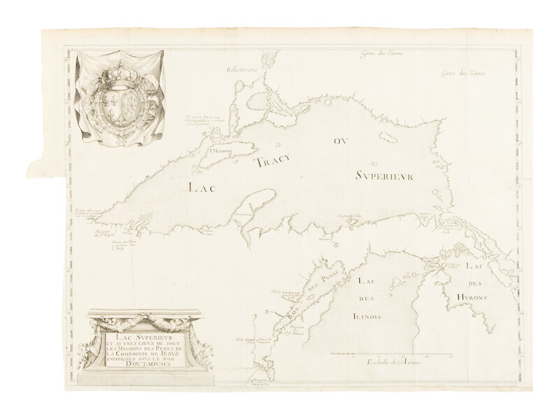
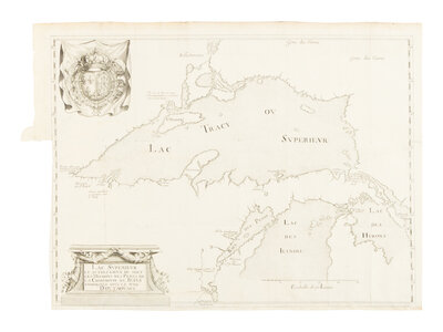
[MAP]. DABLON, Claude (1618-1697). Lac Superieur et autres lieux ou sont les missions des peres de la Compagnie de Iesus comprises sous le nom d'Outaouacs. Paris, 1672.
Engraved map, 375 x 489 mm. Conjoined arms of France and of Navarre in the upper left corner, decorative cartouche with text. (Old folds as issued, neat repair to split at fold near outer margin, some offsetting from text in upper left quadrant verso, lower margin extended with some loss to border, most of left margin trimmed to neatline, very faint dampstaining near lower edge and below conjoined arms, hinges near top edge verso.)
ONE OF THE RAREST AND MOST ACCURATE MAPS RELATING TO THE GREAT LAKES, SHOWING THE SHAPES OF LAKE SUPERIOR AND LAKE MICHIGAN CORRECTLY RENDERED FOR THE FIRST TIME.
"Accompanying the annual report of the Jesuits for 1672 in the famous 'Jesuit Map' showing Lake Superior, the whole of the Upper Peninsula and part of the Lower Peninsula. It is not only a beautiful map, but also the most nearly accurate of the Michigan country published during the first century and a half of European exploration in the New World. It is worth noting D'Ablon, the author of the Report, was a Jesuit missionary in Canada for over forty years" (One Hundred Michigan Rarities).
Born in Dieppe, France, Claude Dablon joined the Society of Jesus in 1639 and was sent to New France in 1655. His missionary efforts began among the Onondaga Iroquois in present-day New York, where he documented his experiences in the Jesuit Relations. In 1661, he participated in an exploratory expedition with Gabriel Druillettes to Hudson Bay, seeking to establish missions and explore potential trade routes, though this effort ultimately failed. In 1668, he joined Claude-Jean Allouez and Jacques Marquette in founding missions around Lake Superior. Together, they mapped the lake with remarkable accuracy for the time and were among the first Europeans to document its rich copper deposits. Dablon also co-founded the mission at Sault Ste. Marie which became a center for Jesuit activity in the region. Later, he helped establish the mission of St. Ignatius Loyola at St. Ignace, Michigan, near the Straits of Mackinac.
As Superior General of all Canadian Jesuit missions from 1671 to 1693 (with a brief hiatus), Dablon oversaw efforts to expand Catholic influence among Indigenous peoples. He supported Marquette’s exploration of the Mississippi River and ensured that Marquette’s maps and notes were shared with European audiences.
"No one can examine this fine delineation of Lake Superior and the northern parts of Michigan and Huron without amazement at the amount of scientific exploration and careful observation which made it possible. Not until the second quarter of the nineteenth century was any cartographical work of the magnitude and character of this Jesuit map executed in the Great Lakes area" (Karpinski).
EXCEEDINGLY RARE: Only 3 examples found in the trade over the past century, none at auction. Karpinski XIII; Clements, One Hundred Michigan Rarities 3; Clements, 101 Treasures 18.
Property from the Estate of James G. Hansen at Fetcher House, Winnetka, Illinois