Condition Report
Contact Information
Auction Specialist
Lot 221
Sale 6330 - Fine Printed Books & Manuscripts, Including Americana
May 8, 2025
10:00AM CT
Live / Chicago
Own a similar item?
Estimate
$6,000 -
8,000
Price Realized
$17,920
Sold prices are inclusive of Buyer’s Premium
Lot Description
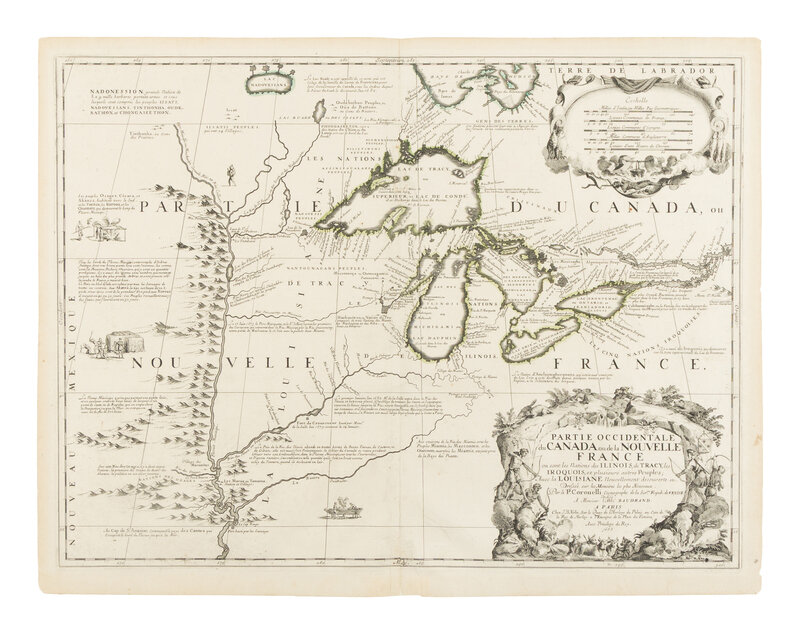
[MAP]. CORONELLI, Vincenzo Maria (1650-1718). Partie Occidentale du Canada ou de la Nouvelle France ou Sont les Nations des Illinois, de Tracy, les Iroquois, et Plusieurs Autres Peuples; Avec la Louisiane Nouvellement Decouverte etc. Paris, 1688.
Engraved map with hand-outlining, 489 x 635 mm. Decorative cartouche, small vignettes including one roasting a man on a spit below the distance scale, one hollowing out a canoe, and another roasting fish. (Some marginal toning, centerfold reinforced on verso, hinged to mat, contemporary manuscript numerals on verso.)
THE FIRST PRINTED MAP DEVOTED TO THE GREAT LAKES AND UPPER MISSISSIPPI REGION.
Coronelli's map is the "finest portrayal since Nicolas Sanson's Amerique Septentrionale, 1650, only requiring little improvement in Lakes Michigan and Huron" and "would remain the definitive map of the region for over fifty years" (Burden). Cartographically, the north shore of Lake Erie depicts the three peninsulas for the first time, and Chekagou R Portage also makes its first appearance along the southern shore of Lake Michigan. Lake Superior is considerably more accurate and based on the account of Father Claude Dablon.
BURDEN'S SECOND STATE with the date updated and the coat of arms added. Eight new placenames are placed on the southern shore of Hudson Bay, including Fort St. Louis, and two on the north-west shore of Lake Superior. Interestingly, none of these appear on Coronelli's later reduction published in Venice, 1695. The first state only survives in one example. Burden 630; Karpinski, pp.110, 117; Kershaw 158; Verne & Stuart-Stubbs 19.
Property from the Estate of James G. Hansen at Fetcher House, Winnetka, Illinois