
Condition Report
Contact Information
Lot 65
Sale 610 - Fine Cartographic and Printed Americana
Nov 12, 2018
9:59AM
Live
Own a similar item?
Estimate
$1,000 -
1,500
Price Realized
$1,500
Sold prices are inclusive of Buyer’s Premium
Lot Description
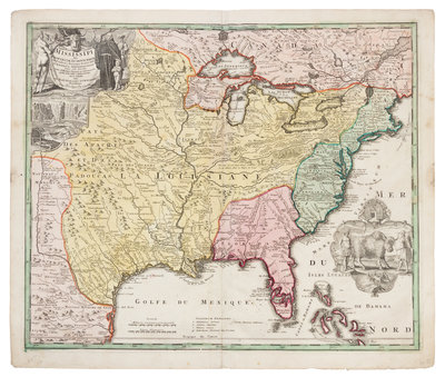
HOMANN, Johann Baptist (1663-1724). Amplissimae Regionis Mississipi. Nuremberg, [ca 1720 or later].
Engraved map of the Mississippi River valley and Great Lakes, with hand-coloring in outline and wash, image 485 x 577 mm (sheet 535 x 640 mm). Cartouche depicting Father Louis Hennepin, inset of Niagara Falls, cartouche with vignette of a buffalo and Native Americans. (Remnant of stub to fold on verso.) Homann's map, based on Delisle's map of 1718 but covering a slightly larger area, also details the Gulf Coast and includes Mission de los Teyas in present-day Texas. Phillips dates the map to the 1720s, but Wheat dates it circa 1763. See Phillips 622 (v.I, no.139); see Phillips 4257 (v.7, no.98); Wheat Transmississippi 144.