
Condition Report
Contact Information
Lot 49
Sale 610 - Fine Cartographic and Printed Americana
Nov 12, 2018
9:59AM
Live
Own a similar item?
Estimate
$1,000 -
2,000
Price Realized
$1,188
Sold prices are inclusive of Buyer’s Premium
Lot Description
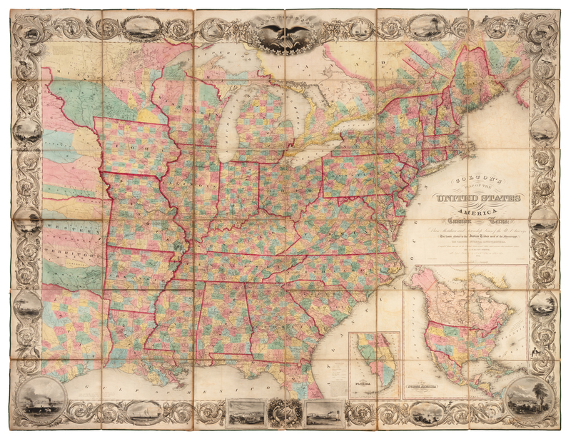
COLTON, Joseph Hutchins (1800-1893). Colton's Map of the United States of America, including Canada and a large portion of Texas. New York, 1854.
Engraved folding map, overall 1665 x 2068 mm, hand-colored in wash and outline, dissected in 36 sections and mounted on linen, green selvage, marbled paper outer panels. (Some fraying with losses to small areas of selvage, a few small separations in linen at folds, some minor browning or offsetting, otherwise fine.)Later edition, from surveys by J. Calvin Smith, with vignettes in the engraved border, which first appeared in the 1853 edition. The vignettes depict the principal cities, including Cincinnati, Boston, Portland ME, New Haven, Richmond, New York, Baltimore, Philadelphia, Washington, Charlestown, New Orleans, Nashville, St. Louis, and Louisville. Inset lower right with a map of North America. Rumsey 2834.