
Condition Report
Contact Information
Lot 103
Sale 610 - Fine Cartographic and Printed Americana
Nov 12, 2018
9:59AM
Live
Own a similar item?
Estimate
$1,000 -
2,000
Price Realized
$3,750
Sold prices are inclusive of Buyer’s Premium
Lot Description
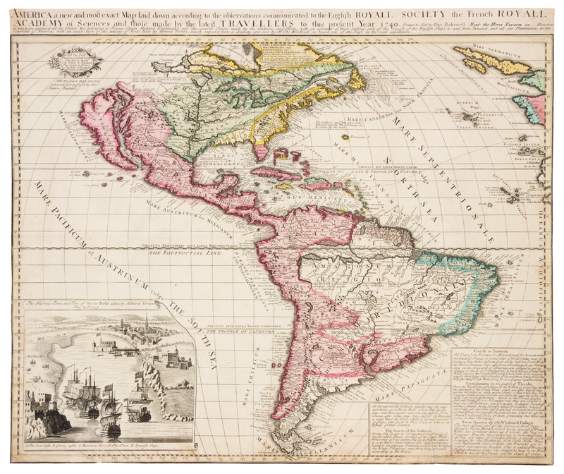
[PORTO BELLO]. America a new and most exact Map laid down according to the observations communicated to the English Royall Society the French Royall Academy. London: Thomas Bakewell, 1740.
Engraved map of the Americas, with hand-coloring in outline and wash, image and sheet 508 x 600 mm. Inset of British and Spanish ships in the harbor at Porto Bello, decorative cartouche. (2 -in. tear lower right repaired on verso, trimmed to neatline.) FIRST EDITION of Bakewell's map, issued to commemorate Admiral Edward Vernon's naval victories in the Caribbean at the outset of the War of Jenkins' Ear. The inset depicts the British capture of Porto Bello, a silver-exporting town on the coast of Panama, on 22 November 1739, and bears that date. Admiral Vernon captured the poorly-defended port within 24 hours using 6 ships. Copies of this map are known to exist with side and bottom panels depicting Cartagena, Havana, the silver mines of Potosi, scenes of Virginia, Florida, Mexico and Brazil, and a chart of contemporary nautical weapons. The map was reissued in 1748 to celebrate the conclusion of the war. VERY SCARCE: We do not trace any copy of this map at auction in the last 40 years. Only three other copies of this map are known, and all are held in institutional collections: The British Library (without the side or bottom panels), Colonial Williamsburg (without the side or bottom panels), and the Clements Library at the University of Michigan (with the side and bottom panels).