Condition Report
Contact Information
Lot 149
Lot Description
Folie, A.P.
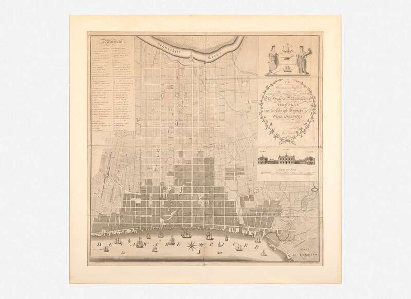
To Thomas Mifflin Governor and Commander in Chief of The State of Pennsylvania This Plan of the City and Suburbs of Philadelphia...
(Philadelphia: Richard Folwell), 1794. Engraved map by R(obert). Scot and S(amuel). Allardice after the survey by Folie. Map: 25 x 25 3/8 in. (635 x 644 mm); sheet: 29 x 28 3/4 in. (737 x 730 mm). Second state (with titles printed above buildings below cartouche). Creasing from contemporary folds, scattered separations and small losses along same; small losses and short closed tears along edges; tape repairs on verso; faint spotting in inset and in map. In mat, 29 7/8 x 30 in. (759 x 762 mm). Deak 199; Snyder, City of Independence 152A; Phillips, A Descriptive List of Maps and Views of Philadelphia 173; Wheat & Brun 462; Stauffer 2865; Ristow, p. 250
Excessively rare map of Philadelphia, the first great plan of the city while the nation's capital. Bounded by the Schuylkill River at top and the Delaware River at bottom, this detailed map is based on surveys conducted by French geographer Antoine Pierre Folie, and was issued with bookseller Benjamin Davies's guide to the new capital city, Some Account of the City of Philadelphia… (Philadelphia: Richard Folwell, 1794).
The legend at top left lists 64 important locations throughout the city, including numerous churches and meetinghouses, including the “Jewish Synagogue” (Congregation Mikveh Israel), and the “African Meeting House” (Mother Bethel A.M.E.). Other locations include Charles Willson Peale's Museum, the Bank of the United States, Pennsylvania Hospital, John Bill Ricketts's Circus (the first in America), and many more. The various buildings of the federal and state governments are depicted, including the intended President's House at Ninth Street between Chestnut and Market. Washington never stayed there, and instead chose to rent Robert Morris's house at Sixth and Market for his residence and office—it then became the University of Pennsylvania’s second campus. Also depicted is the War Office, the State House, Congress Hall, and the City Court House, the latter three rendered in fine detail below the cartouche.
In his City of Independence, Snyder lists two states of this map, the first state without the buildings under the cartouche named, and this second “later” state, with those same buildings identified as “City Hall,” “State House,” and “Congress Hall,” respectively. Rare in any state, we can locate only four other examples in the available auction record since 1910. Examples of this second state are held at the New York Public Library and the John Carter Brown Library.