Condition Report
Contact Information
Auction Specialist
Lot 285
Sale 1095 - American Historical Ephemera & Photography, Featuring Property from the James Milgram, M.D., Collection of Broadsides, Ephemeral Americana & Historical Documents
Day 1 Lots 1-403
Nov 3, 2022
10:00AM ET
Day 2 Lots 404-634
Nov 4, 2022
10:00AM ET
Live / Cincinnati
Own a similar item?
Estimate
$600 -
800
Price Realized
$875
Sold prices are inclusive of Buyer’s Premium
Lot Description
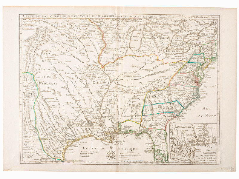
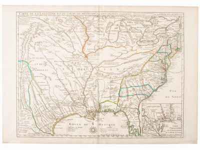
[MAPS & ATLASES -- MISSISSIPPI RIVER]. DEZAUCHE, J.A. (fl. 1780-1838) after Guillaume DELISLE (1675-1726). Carte de la Louisiane et du Cours du Mississipi avec les Colonies Anglaises. Paris: Dezauche, [1782].
Engraved map of the early American colonies, image 25 x 18 5/16 in. (sheet 30 x 21 1/8 in.). Inset of New Orleans and the Mississippi River Delta, "Carte Particuliere des Embouchures de la Rivie. S. Louis et de la Mobile." (Minor toning at sheet edges, two small dampstains contained to lower margin.) Matted.
A late edition of Delisle's important North American map showing the American colonies prior to the Treaty of Paris. Considered the most accurate depiction of the Mississippi River and its tributaries to date, providing credible routes for Moscoso (1540, 1542), La Salle (1687), and de Leon (1689). Also with an improved depiction of Texas, river, and updated placenames not located on earlier editions. Notably, "Mission de los Teijas" marks the first appearance of a form of the name "Texas" on a printed map, establishing Texas as a geographic place name.
Eiteljorg Museum of American Indians and Western Art
This lot is located in Cincinnati.