Condition Report
Contact Information
Lot 225
Sale 800 - Fine Books and Manuscripts
Lots 1-273
Nov 12, 2020
4:00AM CT
Lots 274-476
Nov 13, 2020
4:00AM CT
Live / Chicago
Own a similar item?
Estimate
$2,500 -
3,500
Price Realized
$5,250
Sold prices are inclusive of Buyer’s Premium
Lot Description
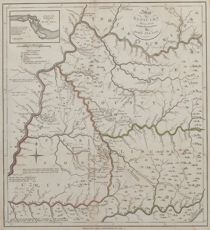
FILSON, John (ca 1747-1788). A Map of Kentucky Drawn From Actual Observations. London: John Stockdale, 1793.
Engraved map with hand-coloring in outline, sheet 509 x 468 mm. Inset map "A Plan of the Rapids in the River Ohio," compass rose. (All edges tipped to backing board, separation with small loss along center fold, 3 1/2-in. tear crossing border and image, some minor spotting.)
Based on Filson's map of 1784, this edition, published 23 November 23 1793, appeared in Stockdale's edition of Filson's The Discovery, Settlement and Present State of Kentucky (1793) and two different 1794 editions of Jedidiah Morse's The American Geography; Or, A View of the Present Situation of the United States of America. Despite numerous smaller-format versions of Filson's 1784 map, the 1792 Stockdale edition is the only other full-sized edition of the map, and is the only obtainable full-sized edition of Filson's map. Filson created the map to be included with his The Discovery, Settlement and Present State of Kentucke (see previous lot), though the map is rarely found with copies of the work.
Property from the Estate of Mary Patricia Reynolds, Bowling Green, Kentucky