
Condition Report
Contact Information
Lot 858
Sale 739 - Interiors
Lots Open
Feb 25, 2020
Lots Close
Feb 26, 2020
Timed Online / Chicago
Own a similar item?
Estimate
$80 -
120
Price Realized
$63
Sold prices are inclusive of Buyer’s Premium
Lot Description
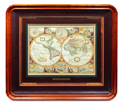
[MAPS -- WORLD AND UNITED STATES]. Two maps, comprising:
[FACSIMILE]. SPEED, John (1552-1629). A New and Accurate Map of the World... N.p., 20th century. Printed in color. 15 x 20 inches matted and framed (not examined out of frame).
[With:]
BACHE, Alexander Dallas. U. S. Coast Survey...Sketch A Shewing the progress of the Survey in Section No. I From 1844 to 1861. Philadelphia: Bowen & Company, 1861.
Lithographed map hand-colored in wash and outline, visible area 20 x 30 1/4 in. (768 x 510 mm), matted and framed (unexamined out of frame). Showing Cape Cod, and the Massachusetts and New Hampshire coast line. (Some toning and a few small separations along folds.)
Property from the Collection of Lori Dodwell, Leland Grove, Illinois