
Condition Report
Contact Information
Lot 386
Sale 697 - Fine Books and Manuscripts including Americana
Nov 6, 2019
10:00AM CT
Live / Chicago
Own a similar item?
Estimate
$1,500 -
2,500
Price Realized
$1,875
Sold prices are inclusive of Buyer’s Premium
Lot Description
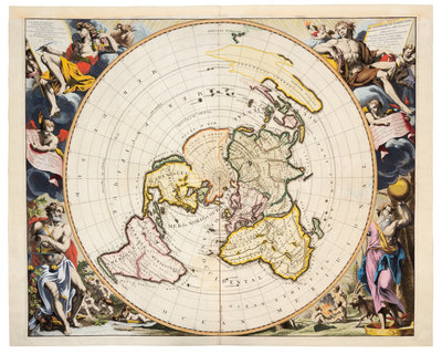
VAN DER AA, Pieter (1659-1733). Planisphere Terrestre Suivant les nouvelle Observations de Astronomes... Leiden, 1713.
Engraved world map on a north polar projection, sheet 22 5/8 x 28 3/8 in. (574 x 720 mm), with hand-coloring. (Upper margin renewed, 7 -in. tear along fold repaired on verso.) Allegorical border by Jan Goeree and engraved by Gilliam van der Gouwen, more than 40 astronomical stations marked in orange, including Quebec, the Cape of Good Hope, Goa, and Peking. Van der Aa's map is derived from the Cassini-Nolin map of 1696, widely considered the first "scientific" map of the world.