
Condition Report
Contact Information
Auction Specialist
Lot 259
Sale 6356 - American Historical Ephemera and Photography
Lots Open
Jun 18, 2025
Lots Close
Jul 2, 2025
Timed Online / Cincinnati
Own a similar item?
Estimate
$300 -
500
Price Realized
$183
Sold prices are inclusive of Buyer’s Premium
Lot Description
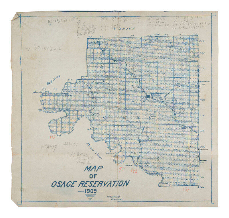
[MAPS]. Map of Osage Reservation, 1909.
MASSEY, R.R., Draftsman. Map of Osage Reservation, 1909. N.p.: [R.R. Massey?], 1909. Blueline process. 14 1/4 x 13 3/4 in. (creasing at folds, pencil notations, light soil and wear).
Very scarce. We locate no sales of this map at auction. OCLC locates one copy in the collections of the Newberry Library. Map may have been a part of a larger plat book of the Osage Reservation.
In the 19th century, the Osage were forced by the United States to move from modern-day Kansas into Indian Territory (present-day Oklahoma). In the late 19th and early 20th century, oil was discovered on their land. Mineral reserves were given by law to the Osage Nation in 1906. In 1907 individual tribal members were given “headrights” or shares of income from the mineral rights held by the tribe. This section, township and range map was created just after these historic events. Many Osage became wealthy through returns from leasing fees generated by their headrights, but during the 1920s "Reign of Terror" they suffered manipulation, fraud, and murders by outsiders eager to take over their wealth.
This lot is located in Cincinnati.