
Condition Report
Contact Information
Auction Specialist
Lot 239
Sale 6330 - Fine Printed Books & Manuscripts, Including Americana
May 8, 2025
10:00AM CT
Live / Chicago
Own a similar item?
Estimate
$10,000 -
15,000
Price Realized
$20,480
Sold prices are inclusive of Buyer’s Premium
Lot Description
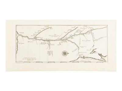
[MAP]. THEVENOT, Melchisedec (1620-1692). Carte de la decouverte faite l'an dans l'Amerique Septentrionale. Paris, 1681.
Engraved map, 225 x 483 mm. Compass rose oriented with north to the right. (Hinged to mat, discreetly remargined close to neatline and laid down).
THE FIRST DEVOTED MAP OF THE MISSISSIPPI RIVER AND PROBABLY THE FIRST TO NAME MICHIGAN.
In 1673, Louis Jolliet (1645-1700), a fur trader, and Father Jacques Marquette (1637-1675), a Jesuit missionary, embarked on a landmark expedition to explore the Mississippi River under French orders. Departing from St. Ignace (Michigan) on May 17 with five voyageurs, they traveled by canoe through Green Bay, ascended the Fox River, and portaged to the Wisconsin River before reaching the Mississippi on June 17. Paddling south, they documented the river’s course, interacted with Indigenous nations, and reached the Arkansas River by July, confirming the Mississippi flowed into the Gulf of Mexico—not the Pacific—before turning back to avoid Spanish territories. On their return, they discovered a new route back to Lake Michigan along the Illinois and Des Plaines River to the portage through the site of present-day Chicago. Lac de Michigami ou Illinois is its first mention on a map. Their account, Recueil des Voyages, was first collected and published in 1681 by Thevenot with further editions in 1682, 1687, and 1689. Though Marquette’s journal survived, Jolliet’s records were lost when his canoe capsized near Montreal. The present map is likely based on the earliest and most accurate surviving manuscript cartographic record in the Archives de la Compagnie de Jesus, Saint-Jerome, Quebec, and known as the Marquette map.
The map here is in the third state with the date 1673, as usual; Burden posits that the first two states (each known in a single copy) were almost certainly proofs. EXCEEDINGLY RARE: According to online records, the map has only been offered at auction with the published work (Recueil des Voyages) once in the past 25 years. It has never appeared on its own.
Celebration of My Country 11; Church 672; Clements One Hundred Michigan Rarities 4; Graff 4122; Greenly 6; Harrisse 147; Howes T156; Hubach p.9; JCB Catalogue pp. 90-91; Jones 320; European Americana 681/141; Sabin 95332; Streeter sale 1:101.
Property from the Estate of James G. Hansen at Fetcher House, Winnetka, Illinois