Condition Report
Contact Information
Auction Specialist
Lot 236
Sale 6330 - Fine Printed Books & Manuscripts, Including Americana
May 8, 2025
10:00AM CT
Live / Chicago
Own a similar item?
Estimate
$2,000 -
3,000
Price Realized
$2,880
Sold prices are inclusive of Buyer’s Premium
Lot Description
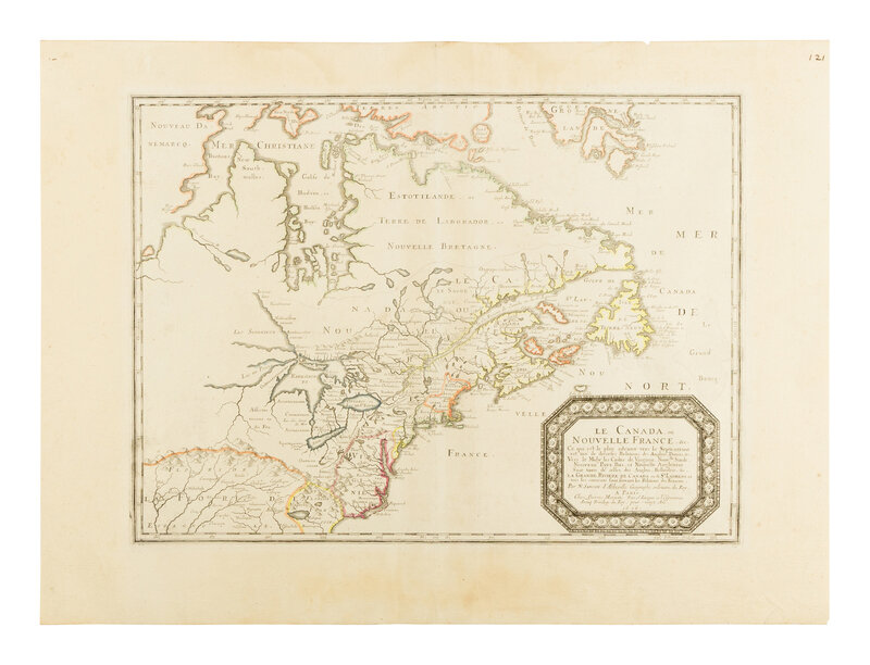
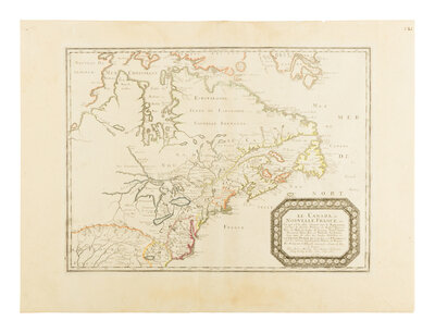
[MAP] SANSON, Nicolas (1600-1667). Le Canada ou Nouvelle France, &c. Paris, 1656.
Engraved map with hand-outlining, 521 x 711 mm. (Margins toned, early manuscript numbering in upper corner, hinged on verso, some dampstaining in upper margin.)
THIS LANDMARK MAP IS THE FIRST OF CANADA TO SHOW ALL FIVE GREAT LAKES AND THE FIRST TO NAME LAKE ERIE ("L. Erie ou Du Chat").
The map reflects Sanson’s positivist approach, prioritizing geographic accuracy over decorative embellishments common in Dutch maps of the era. It incorporates Jesuit missionary explorations, correcting earlier errors such as the depiction of Lake Ontario, which was initially rendered as a river system in Sanson’s 1650 Amerique Septentrionale but corrected here. Sanson also included Hudson Bay details, correcting New Amsterdam’s placement, and adding Long Island, advancing French claims against British and Dutch rivals. Sanson's map "influenced the cartography of Canada for the next fifty years. The eastern Great Lakes region is remarkably accurate, with the western ends of the lakes undefined for lack of reliable information. The possibility of a northwest passage at the bottom of Button's Bay was also to influence a considerable number of cartographers for the rest of the century" (Kershaw). Burden 318; Cumming 48; Karpinski X; Kershaw 13; .Schwartz & Ehrenberg, p.114.
Property from the Estate of James G. Hansen at Fetcher House, Winnetka, Illinois