
Condition Report
Contact Information
Auction Specialist
Lot 356
Sale 6286 - The Collected Library
Lots Open
Mar 5, 2025
Lots Close
Mar 18, 2025
Timed Online / Chicago
Own a similar item?
Estimate
$200 -
300
Price Realized
$640
Sold prices are inclusive of Buyer’s Premium
Lot Description
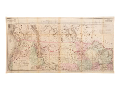
[AMERICANA - MAP]. COLTON, G.W. and C.B. Map of the Country from Lake Superior to the Pacific Ocean from the Latest Explorations and Surveys. New York, 1868.
Lithograph map with original hand-coloring, folded as issued, 584 x 1144 mm. (Several repairs to folds verso, some splits.)
A detailed promotional map illustrating the route of the Northern Pacific Railroad from Lake Superior to the Pacific Ocean was first issued in 1867 to accompany the report of Edwin Johnson on the progress of the railroad.