
Condition Report
Contact Information
Lot 87
Sale 610 - Fine Cartographic and Printed Americana
Nov 12, 2018
9:59AM
Live
Own a similar item?
Estimate
$8,000 -
12,000
Price Realized
$45,000
Sold prices are inclusive of Buyer’s Premium
Lot Description
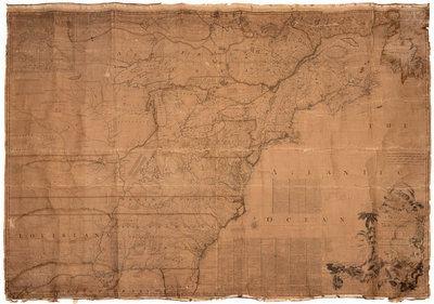
MITCHELL, John (1711-1768). A Map of the British and French Dominions in North America. London, imprint [chipped] 1755[-1757].
Engraved wall map on burlap backing, overall 1378 x 1918 mm. (Browned and stained, chipping and defects to margins affecting neatline and part of the imprint, creased with separations an occasional minor losses, some with old repairs on verso.) Second edition, so stated in the 6th line of the first column of three-column text, and with imprint mentioning Kitchin, Millar, and Katharine Street. Rumsey "believe[s] the second edition is scarcer than the other editions as it appears less often on the market." Mitchell's map, first published in 1755, was issued just prior to the French and Indian War, and is decidedly pro-English in interpretation. The second edition is the first to incorporate two large blocks of text in the Atlantic Ocean. Subsequent editions were published by Jefferys and Faden. Ristow, A la Carte. p.109; Rumsey 2842; Stevens & Tree 54c. Sold not subject to return.