
Condition Report
Contact Information
Lot 56
Sale 610 - Fine Cartographic and Printed Americana
Nov 12, 2018
9:59AM
Live
Own a similar item?
Estimate
$500 -
700
Price Realized
$1,063
Sold prices are inclusive of Buyer’s Premium
Lot Description
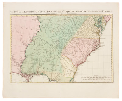
COVENS, Johannes (1697-1774), and Cornelis MORTIER (1699-1783). Carte de la Louisiane, Maryland, Virginie, Caroline, Georgie, avec une Partie de la Floride. Amsterdam: Covens & Mortier, 1758.
Engraved map of the Southeast and the Mississippi River, with hand-coloring in outline and wash, image 412 x 583 mm (sheet 545 x 655 mm). (Short split repaired upper margin, remnants of binding stub along crease on verso.) French, British and Spanish claims are delineated, including claims in dispute by Britain and Spain in Georgia and Florida. The map is based on d'Anville's Canada Louisiane et Terres Angloises of 1755.