
Condition Report
Contact Information
Lot 3
Sale 586 - Made in Chicago
Oct 23, 2018
9:59AM
Live
Own a similar item?
Estimate
$600 -
800
Lot Description
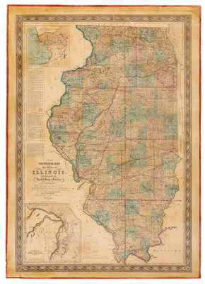
J. H. COLTON. New Sectional Map of the State of Illinois. Compiled From the United States Surveys. [New York, 1852].
Lithographed map with hand-coloring, image 1037 x 712 mm (sheet 1102 x 788 mm). Printed within decorative borders, insets of Galena and St. Louis, untitled profile of the Michigan Canal. (Mounted on new linen, new selvage, a few closed splits just touching image.) Later issue, first published in 1836, based on surveys by J. Peck, J. Messinger, and A. J. Mathewson. The map delineates the state's transportation infrastructure, including roads, canals and rail lines, many converging on Chicago, whose role as an emerging transportation hub was one of the driving forces of growth and development at that time. The map also shows the vast expanse of the Prairie. According to Rumesy, "It is odd that with so many issues of the map, it has become truly scarce...in its time, it was the best map of Illinois by far, and was probably the most popular." COPIES OF THIS MAP ARE RARE AT AUCTION: we trace only two copies in at least 40 years. Rumsey 5030.