Condition Report
Contact Information
Lot 43
Sale 402 - Fine Books and Manuscripts
Nov 11, 2015
3:59AM CT
Live / Chicago
Own a similar item?
Estimate
$500 -
700
Price Realized
$625
Sold prices are inclusive of Buyer’s Premium
Lot Description
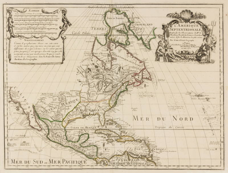
(MAP) DELISLE, GUILLAUME
LAmerique Septentrionale. Paris, 1700 [1708]. Double-page engraved map, hand-colored in outline. Though dated 1700, this is the 1708 reissue of De l'Isle's 1700 map of North America with "sur le Quai de L'Horloge" in the cartouche and Renard's imprint erased in the plate. This map is the first to show the Sargossa Sea; it is "a foundation map...[with] the Great Lakes based on Coronelli showing the French strong points at Tadousac, Quebec, Fort Sorel, Montreal & Fort Frontenac.... In this map De l'Isle corrected longitude positions and was the first to revert to a peninsula form for California. He stops his western coast at Cape Mendocin" (Tooley). Framed and matted.
21 1/2 x 29 5/8 inches.