
Condition Report
Contact Information
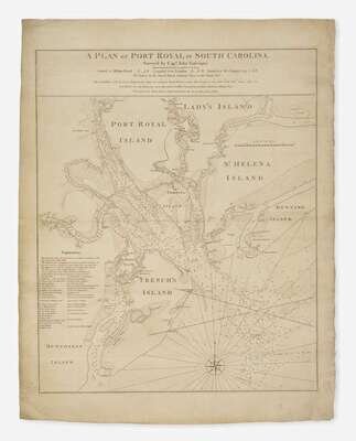
Lot 106
Lot Description
(Faden, William, and Thomas Jefferys)
A Plan of Port Royal in South Carolina...
(London: Jefferys and Faden, ca. 1773-76). First state. Engraved map, by Jefferys and Faden, after a survey by John Gascoigne. Minor creasing and light soiling along edges. 32 1/2 x 25 3/4 in. (825 x 654 mm). Sellers & Van Ee 1529; Steven & Tree 71(a); Cumming, British Maps of Colonial America, pp. 47-49 and The Southeast in Early Maps, 204
A very rare and highly detailed sea chart, the most important map of South Carolina's Port Royal Sound and Hilton Head made in the early days of the Revolutionary War. This very finely engraved and immensely detailed chart was superior to all other maps printed of the region, and the most important portrayal of the Port Royal Sound available in the early days of the Revolutionary War.