Condition Report
Contact Information
Lot 86
Sale 2600 - Books and Manuscripts
Sep 27, 2023
11:00AM ET
Live / Philadelphia
Own a similar item?
Estimate
$2,000 -
3,000
Price Realized
$2,520
Sold prices are inclusive of Buyer’s Premium
Lot Description
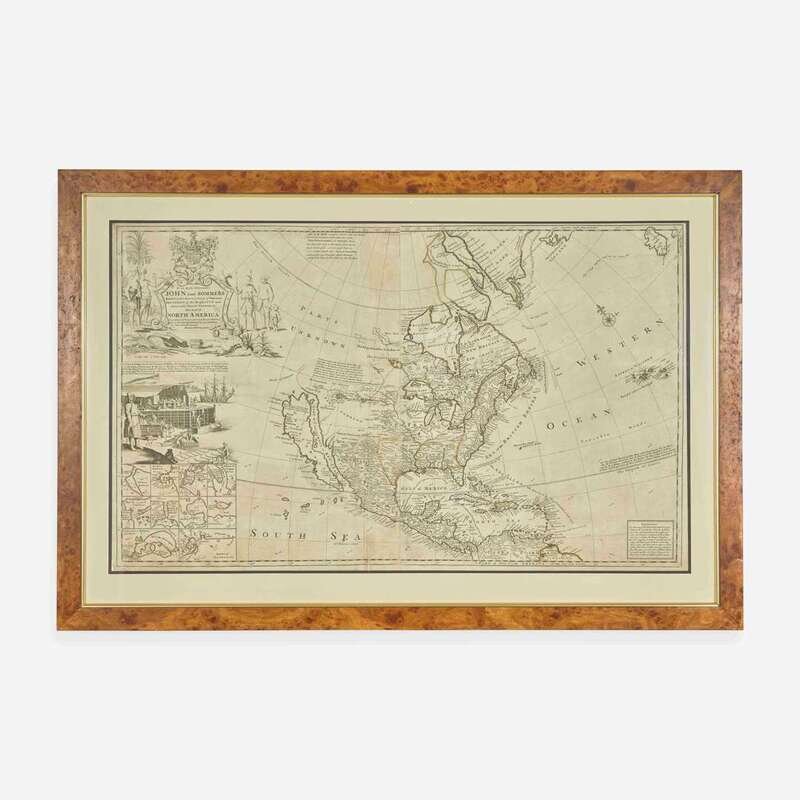
[Maps & Atlases] Moll, Herman
To the Right Honourable John Lord Sommers...This Map of North America According to ye Newest and most Exact Observations...
Hermann Moll's Great "Codfish Map" of North America Moll, Herman
To the Right Honourable John Lord Sommers...This Map of North America According to ye Newest and most Exact Observations...
(London): Printed for I. Bowles, and T. Bowles, et al., (ca. 1720). Engraved map on two joined sheets, with hand-colored outlining; 24 1/4 x 39 1/4 in. (616 x 997 mm). Chipping and repaired scattered closed tears along edges, repaired open tear bottom left; flattened vertical creasing at center; small restoration in ink in bottom center edge; laid down on light wove paper. In mat and in frame, 30 3/4 x 45 3/4 in. (781 x 1162 mm). Tooley 3:82; Schwartz & Ehrenberg, p. 140 Hermann Moll's highly decorative and celebrated "Codfish Map" of North America, one of the earliest large format maps of North America printed in England. Moll's expansive map extends from Greenland to South America, with highly detailed depictions of British, French, Spanish, and Native American territorial claims across the continent. The map extends west to the Pacific Ocean, featuring a late depiction of California as an island, Baron de Lahontan's speculative "Long River" connecting the Mississippi River to the far west, and east into the Atlantic Ocean, showing the Azores, and Ireland to the far north. The Caribbean is depicted showing the routes of Spanish treasure fleets, and their various routes from Veracruz, Panama and Cartagena, to Havana and then across the Atlantic. Moll, one of the most important London mapmakers of the first part of the 18th century, published this map to counter exaggerated French territorial claims in North America, especially as seen in Guillaume Delisle's French map, Carte de La Louisiane de du Cours du Mississipi (1718). Moll's map pointedly minimizes the territory of French Louisiana to south of the Ohio River and enlarges English claims in Canada by labeling Labrador as "New Britain". Popularly referred to as the "Codfish Map" due to the highly detailed vignette at left depicting the Newfoundland codfish industry, a trade dominated by the British at this point, and showing various figures unloading, drying, and curing the lucrative fish. The map also features a large engraved cartouche at top left showing Native Americans and Inuit, as well as an inset view at bottom left showing the plans of 10 important harbors and bays, including St. John's, Newfoundland; Boston; New York; Charlestown; Port Royal Harbour in Jamaica; Havana, Cuba; Porto Bella in Panama; Veracruz, Mexico; Cartagena Harbor and Forts, Colombia; the Port of Acapulco, Mexico. Provenance
Property from a Private New Jersey Collection.