
Condition Report
Contact Information
Lot 81
Sale 2600 - Books and Manuscripts
Sep 27, 2023
11:00AM ET
Live / Philadelphia
Own a similar item?
Estimate
$800 -
1,200
Price Realized
$756
Sold prices are inclusive of Buyer’s Premium
Lot Description
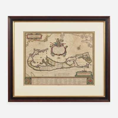
[Maps & Atlases] Blaeu, Willem
Mappa Aestivarum insularum alias Barmudas
Blaeu, Willem
Mappa Aestivarum insularum alias Barmudas
Amsterdam, (ca. 1640). Engraved map with hand-coloring. Latin text on verso. Approximately 16 1/4 x 21 1/4 in. (412 x 540 mm) (sight). In mat and unexamined out of double-pane glass frame, 25 5/8 x 30 1/2 in. (651 x 775 mm). Handsome map of Bermuda, based on the 1617 survey conducted by Richard Norwood on behalf of the Bermuda Company, the first survey of the archipelago. As depicted here, the islands were divided into eight "Tribes," corresponding to the Company's principal shareholders or proprietors, with the land then further divided into smaller lots. A table at bottom lists the over 150 shareholders arranged according to their proprietor, as well as a key to identify their lot on the map and their number of shares. The decorative cartouche at center depicts Neptune astride the Royal Arms holding a ship. Interestingly, the map includes two depictions of Bermuda, the larger one depicting Norwood's survey, and a small depiction below the cartouche showing the island's position and size relative to Cape Cod, Nova Scotia, Virginia, Florida, and England.