

Condition Report
Contact Information
Lot 79
Lot Description
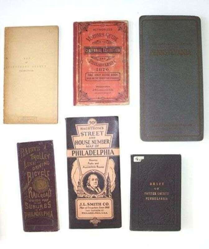
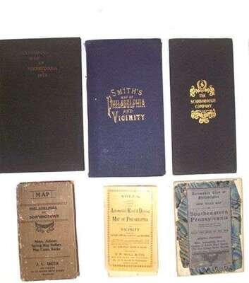
12 pieces. 12 pieces.
Pennsylvania Maps: Sinclair, T., lithographer. "Draft of Porter County, Pennsylvania. 1856." Philadelphia, 1856. Hand-colored fold. litho map, 28 x 21 1/2 inches, orig. cloth casing. A few minor tears along folds. * Sheafer, P.W. "Historical Map of Pennsylvania." Philadelphia: Historical Society, 1875. Hand-colored fold. map. 26 x 40 inches, with orig. text in cloth-bound vol. A few tears along folds. * Visitor's Guide to the Centennial Exhibition. Philadelphia: j.B. Lippincott, (1876). 12mo, orig. bds.; scuffed. With fold. color map, 28 x 21 1/2 inches. * Baist, G. Wm., pub. "Baist's Trolley Line, Driving, Bicycle & Railroad Guide Map to the Suburbs of Philadelphia." Philadelphia, [ca. 1900]. 28 x 21 1/2 inches. * Smith, J.L., pub. "New Map of Philadelphia and Vicinity." Philadelphia, 1907. Fold. linen-backed map, 27 1/2 x 44 1/2 inches. In orig. blue cloth casing. Minor separations along folds. * Smith, J.L. "Map, Philadelphia to Downingtown." Philadelphia, 1907. Fold. linen-backed map, 26 1/2 x 43 inches. In orig. flexible cloth casing. * Scarborough Company. "Scarborough's Map of Pennsylvania." Boston, 1907. Fold. color map, 38 x 52 inches. In orig. cloth casing. A few small splits along folds. * Hammond, C.S., pub. "The Automobile Club of Philadelphia Road Map of Southeastern Pennsylvania." New York, 1915. Fold. linen-backed partly colored map, 42 x 30 inches. In orig. marbled bds. casing. Casing chipped, minor separations along folds. * Noll, E.P., pub. "Noll's New Automobile Road and Driving Map of Philadelphia and Surrounding Country." Philadelphia, 1920. Fold. map, 44 1/2 x 27 1/2 inches. In orig. flexible bds. casing. Occasional wear along folds. * State Highway Dept. "Map of Public Roads in Montgomery County, Pennsylvania." Baltimore: A Holn, 1923. Fold. color map, 23 x 38 inches. In orig. flexible casing. A few small tears along folds. * State Highway Dept. "Map of Public Roads in Chester County, Pennsylvania." N.p., 1923. Fold. linen-backed color map, 38 1/2 x 40 inches. In orig. worn flexible cloth casing. Minor dust soiling to map, minor separations along folds. * National Survey Co. "The Official Map of Pennsylvania." N.p., ca. 1920s. Fold., partly colored map, 36 x 48 inches. Orig. bds. casing. Minor wear to map.