Condition Report
Contact Information
Auction Specialist
Lot 597
Sale 1095 - American Historical Ephemera & Photography, Featuring Property from the James Milgram, M.D., Collection of Broadsides, Ephemeral Americana & Historical Documents
Day 1 Lots 1-403
Nov 3, 2022
10:00AM ET
Day 2 Lots 404-634
Nov 4, 2022
10:00AM ET
Live / Cincinnati
Own a similar item?
Estimate
$100 -
150
Lot Description
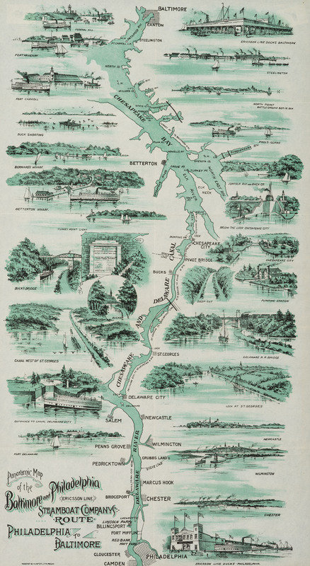
[TRANSPORTATION]. Panoramic Map of the Baltimore and Philadelphia Steamboat Company's Route. Philadelphia: Webster & Hunter, ca 1897.
11 7/8 x 21 5/8 in. lithographed map; framed to 14 1/4 x 23 3/4 in. (not examined out of frame).
An illustrated map showing the Steamboat route between Baltimore and Philadelphia along the Chesapeake Bay, the Chesapeake and Delaware Canal, and the Delaware River. Enhanced with vignettes of the towns and sites along the route. The Canal was opened in 1829, though a waterway was conceived as early as the 17th century to connect the nearby bodies of water. The Baltimore and Philadelphia Steamboat Company, also known as the Ericsson Line named after its first ship, opened shortly thereafter in 1844 and operated until 1934. RARE: only one other copy located, with imprint of the Anvil Print Company in the lower right.
Property from the James Milgram, M.D., Collection of Broadsides, Ephemeral Americana, and Historical Documents